

Aviation Charts, 101
For those of you unfamiliar with some of the types of charts used in real-world aviation as well as by many WestWind pilots as they fly their sim routes, here is some very basic info.
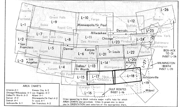
Figure 1 - Low Level Enroute Chart diagram for USA
This scan shows the numbers of the Enroute Low Level charts covering the U.S. When ordering or asking for these charts, ask for them by number, and you might get what you want. The charts come printed with one on the front and the other on the back. Example: This scan was done from chart L-17/L-18. If you wanted Florida, you would need chart L-19/L-20
These Low Level Enroute Charts are intended for Electronic navigation below 18,000 feet, and show very little in the way of landmarks. Information shown on these charts include VOR's and frequencies, airports, Victor Airways and their associated magnetic courses, enroute intersection names, DME (distance measuring equipment) miles for intersection locations, ARTCC sector frequencies (Air Route Traffic Control Centre, commonly referred to as just "XXX Centre"), Class B and C airspace boundaries, special use airspace boundaries (i.e. restricted areas and MOA's) and NDB locations, names and frequencies. Use Low Level charts to navigate electronically (i.e. IFR) between airports.
World Aeronautical Charts (WACs)...
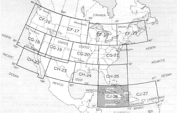
Figure 2 - WAC for USA and Carribbean
This scan shows which WAC (World Aeronautical Chart) covers which geographic are in the U.S. and Carribbean. When ordering, ask for them by number. Example: Chart CG-21 covers North and South Carolina, Eastern Tennessee, Virginia, etc. WAC's have a scale of 1:1,000,000, so they cover about twice the area of a Sectional chart.
WAC's have much more of the same information as a Sectional chart, only in less detail. This information includes airports, cities, colour coded elevations and terrain features, location and terrain feature names, swamps, lakes, rivers, roads, railroads, airports, obstructions, powerlines, pipelines, special use airspace, Class B, C and D airspace, Victor airways, VOR's, NDB's and their associated frequencies. There is not however enough information to navigate solely on instruments in the real world. That requires Low Level Enroute Charts. Simulator pilots might get away with it, though, since they aren't subject to ramp checks.:)
You will not find approach information or frequencies on a WAC chart.
Sectional Aeronautical Charts (WACs)...
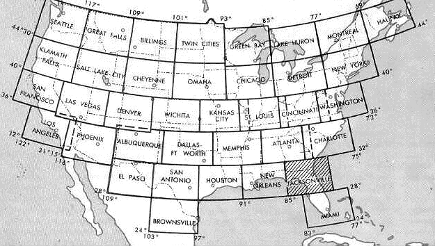
Figure 3 - Sectional Charts for USA
This scan shows which Sectional Aeronautical Chart covers what geographic area of the U.S. When ordering, ask for them by name. This scan was taken from the Jacksonville Sectional, to go south, you'd need a Miami Sectional. Sectional charts are intended for Visual Navigation, which implies and altitude of less than 18,000 feet. Most pilots will have at least the sectional for their home area in their flight bags.
The scale of a Sectional is 1:500,000, and they are published approximately every 6 months. Sectional's are colourful maps with a wealth of information, including colour-coded depictions of elevations, airports, cities, swamps, lakes, rivers, roads, railroads, airports, obstructions, powerlines, pipelines, special use airspace, Class B, C and D airspace, Victor airways, VOR's, NDB's and their associated frequencies. There is not, however, enough information to navigate solely on instruments in the real world. That requires a Low Level Enroute Chart. Simulator pilots might get away with it, thought, since they aren't subject to ramp check.:)
You will not find the approach information or frequencies on a Sectional Chart.
U.S. Terminal Procedures Plates (Approach Plates or "Flips")...
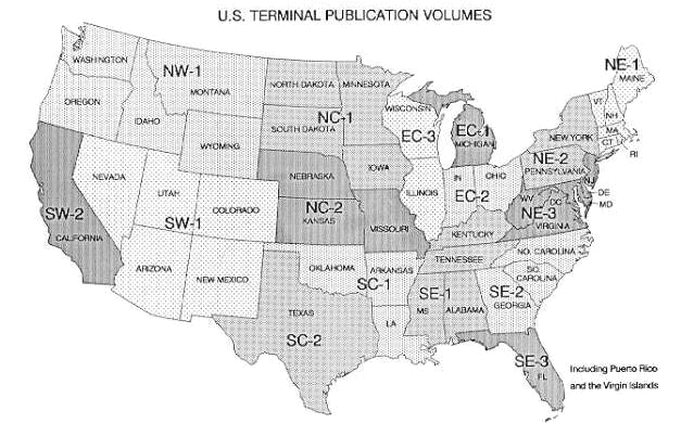
Figure 3 - Approach Plate Charts for USA
This scan shows which NOS (National Ocean Service) U.S. Terminal Procedures Publication, that's Approach Plate Book in non-government speak, covers which states. Example, Book EC-3 covers Illinios and Wisconsin and Book SW-2 covers California.
The information in these books includes what is necessary to transition from the en-route phase of your flight to the approach to landing phase, then fly the published approach. Also included is a graphical depiction of the approach, and another of the airport and taxiway layout for each airport for which an approach is available. These charts are commonly referred to as Approach Plates. Navaid frequencies, including ILS, VOR and NDB's are listed, as well as voice frequencies. Missed approach procedures are shown, as are the course and altitude information for each segment of each approach.
These books, or their equivalent's published by Jeppesen are absolutely essential for the instrument pilot to have in the cockpit in order to have the information he needs to safely complete his flight.
Other types of charts include...
Chart FAQs (how to find them? where to buy? cost? etc.)
There are two different ways to acquire Charts. You can either purchase them or acquire an old set from a real world pilot. The charts are updated on a regular basis. The old charts can no longer be used by real world pilots, but they can still be used by Flight Sim pilots. In fact, a chart published around the time the software is released is usually perfect.
So, if you know a real world pilot, then ask them to collect some of their out of date charts and give them to you. You could also enquire at your local pilot shop or Aero Club for old charts that they no longer need.
Where Can I Get Them From?
Charts can be purchased from a variety of sources including government agencies like NOS and NOAA, from flying organisations like AOPA, from various flying catalogues like Sporty's and from pilot shops which are usually located near smaller airports.
Not really. Individual charts are not very expensive. They usually range somewhere between $5 and $9 each. If you are looking for information on a specific area, your investment won't be huge. If, however, you want charts and approach plates for the entire USA, then you many want to start saving now.
You can probably get away with your choice of either High or Low Level Enroute Charts (which will help you navigate cross country) and Sectional's for the regions you fly to. If you want to make real-world-like approaches and landings, you should also get Terminal Approach Procedure Plates for the airports you fly to.
Another approach, if you're into heavy detail may be to buy WACs, Sectional's and Terminal Approach Plates. Substitute WACs for Enroute Charts. With this approach, particularly if you're flying cross-country, across more than one state, your chart investment may be slightly higher.
Yes, in an extremely high percentage of the time. We've only seen a few discrepancies and even when they occur, they're not far off. Sure beats the alternative of trying to fly VFR in a turboprop or jet. ;-)
Charts add much realism to flying sims, they will give you a greater appreciation for, and understanding of, real world navigation and instrument flying. The bottom line is they're worth the investment.
NOT TO BE USED IN REAL WORLD FLIGHT. NO PARTS OF THIS ARTICLE MAY BE REPRINTED WITHOUT THE WRITTEN PERMISSION OF THE AUTHOR.

|
Airline Operations Hub Operations -Hubs -Mini Hubs -Satellite Airports Cargo Operations Charter Operations Regional Operations |
Training Std. Operating Procedures Pilot Promotion Scale Initial Training Transition Training Advanced Training Six Month Checkrides |
Aircraft & Scenery Main Page Fleet Scenery Online Ops & Events Main Page GAAR |
Personnel Main Page Update Details Pilot Roster Job Postings Recognition Awards Crew Resources Change Password |
Help FAQ Rules & Regulations Personnel Polices Management Directory |
WestWind Monthly Newsletter -Current Issue -Past Issues About WestWind Contact Us Forum |
| Main Website PHP version: 7.4.33 - Page Version 1.0 - Last Updated 10th June 2022 |